
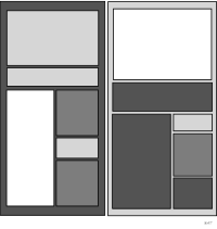
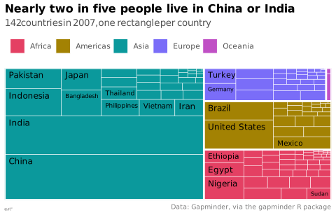


 graphique
carte de carrés
aussi : treemap, carte proportionnelleHiérarchie pavée par des rectangles emboîtés proportionnels.
treemap
Hierarchy tiled with nested rectangles sized by value.
Le terme anglais reste très employé en français.
Classification
- graphique
- secteurs, pavages et unités › pavages
- partie d'un tout; Visual Vocabulary du Financial Times
- le nom évoque : nature
Canaux
 aire; principal : valeur (Munzner : marques d'aire et emboîtement); Munzner 2014
 région de l'espace; principal : hiérarchie (emboîtement); Munzner 2014
 teinte; secondaire : catégorie; Munzner 2014
Variantes
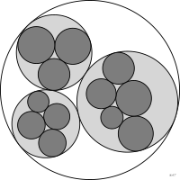 ensemble de cerclescercles
Attestation et synonymies
- terme français : Lagnel, Manuel de datavisualisation, Dunod, 2021
- définition anglaise : Data Visualisation Guide, data.europa.eu
- carte de carrés; Lagnel, Manuel de datavisualisation, Dunod, 2021
Littérature scientifique
OpenAlex : 1 857 articles depuis 1992, dont 32 % ces cinq dernières années; surtout en Computer Science, Social Sciences, Agricultural and Biological Sciences; Wikidata
Références séminales
- premier usage connu (1874) Walker (1874). Statistical Atlas of the United States, Based on the Results of the Ninth Census; Ciuccarelli 2026
- formalisation (1991) Johnson & Shneiderman (1991). Tree-maps: a space-filling approach to the visualization of hierarchical information structures. Proceedings Visualization '91 (637 citations)
- diffusion (1992) Shneiderman (1992). Tree visualization with tree-maps. ACM Transactions on Graphics (1 338 citations); Friendly & Denis 2001
Paquets R
- R
treemapify::geom_treemap(); GitHub 223 étoiles; dernier commit 2026-07
Code R de l'exemple ggplot2
library(ggplot2)
library(treemapify)
library(dplyr)
library(gapminder)
population <- gapminder |>
filter(year == 2007)
p <- ggplot(population, aes(area = pop, fill = continent, subgroup = continent, label = country)) +
geom_treemap(colour = "white", size = 0.5) +
geom_treemap_subgroup_border(colour = "white", size = 2.5) +
geom_treemap_text(family = "Quicksand", colour = "black", place = "topleft",
padding.x = grid::unit(1.5, "mm"), padding.y = grid::unit(1.5, "mm"),
size = 9, min.size = 6) +
scale_fill_manual(values = continent_colors) +
labs(title = "Nearly two in five people live in China or India",
subtitle = "142 countries in 2007, one rectangle per country",
fill = NULL,
caption = "Data: Gapminder, via the gapminder R package") +
theme_lex_viz(grid = "", arrows = "")Sources (50)
460 occurrences dans le corpus; indexé par 18 ouvrages
Afficher les 50 sources
- app.flourish.studio
- Atlas of knowledge: anyone can map
- Better data visualizations: a guide for scholars, researchers, and wonks
- Bremer & Barone, Chart, CRC Press, 2025
- Data fluency: empowering your organization with effective data communication
- Data points: visualization that means something
- Data Visualisation Guide, data.europa.eu
- Data visualisation: a handbook for data driven design
- Data visualization handbook
- Data visualization: a practical introduction
- Data Viz Project
- Data-driven storytelling
- data-to-viz.com
- datavizproject.com
- datawrapper.de↗
- Design for information: an introduction to the histories, theories, and best practices ...
- Effective data storytelling: how to drive change with data, narrative, and visuals
- Effective data visualization: the right chart for the right data
- Elavsky, Chartability : heuristiques d'accessibilité POUR-CAF
- Exploratory Data Analysis: Descriptive Analysis, Visualization, and Dashboard Design (w...
- Focus+context display and navigation techniques for enhancing radial, space-filling hie...
- From data to viz
- Fundamentals of computer graphics
- Handling and mapping geographic information
- How charts lie: getting smarter about visual information
- Information theory tools for visualization
- Interactive data visualization: foundations, techniques, and applications
- Lagnel, Manuel de datavisualisation, Dunod, 2021
- Les fondamentaux de la visualisation de données
- Manuel de datavisualisation - 2e éd, vol. 2
- Milestones in the history of thematic cartography, statistical graphics, and data visua...
- More Practical Charts
- Practical charts: the essential guide to creating clear, compelling charts for reports ...
- Progressive Data Analysis: Roadmap and Research Agenda
- python-graph-gallery.com
- The big book of dashboards: visualizing your data using real-world business scenarios
- The book of circles: visualizing spheres of knowledge
- The book of trees: visualizing branches of knowledge
- The eyes have it: A task by data type taxonomy for information visualizations
- The grammar of graphics
- Thematic Cartography and Geovisualization
- Visualization Analysis and Design
- Visualization of Time-Oriented Data
- Visualize This
- Visualizing with text
- Wickham, Navarro & Pedersen, ggplot2: Elegant Graphics for Data Analysis, 3e éd. en ligne↗
- Wikipedia — Data and information visualization
- Wikipedia in English↗ fr
- Wilke, Fundamentals of Data Visualization, O'Reilly, 2019
- xeno.graphics↗
Citer cette fiche
Adresse stablehttps://dataviz.adrientaudiere.com/terme/treemap.html
RéférenceTaudière Adrien. 2026. carte de carrés. Dans Visualization Vocabulary, version 1.0.0. IdEst. https://dataviz.adrientaudiere.com/terme/treemap.html
BibTeX
@incollection{taudiere2026-treemap,
  author    = {Taudière, Adrien},
  title     = {carte de carrés},
  booktitle = {Visualization Vocabulary},
  year      = {2026},
  version   = {1.0.0},
  publisher = {IdEst},
  url       = {https://dataviz.adrientaudiere.com/terme/treemap.html},
  note      = {CC0 1.0}
}Fiche créée le 13/10/2026. Texte modifié le 12/11/2026. Images modifiées le 02/11/2026. Chiffres calculés le 22/10/2026.